The
Artemis I mission, launched in 2022, involved sending an uncrewed Orion
spacecraft into orbit around the Moon and bringing it back to Earth.
Artemis II will be a crewed mission, launching four astronauts into a
free-return orbit around the Moon and back to Earth, the first time
humans will have been in lunar orbit since 1972. The mission had been
delayed until September 2026 due to technical problems, but has now been
brought forward to April of next year or possibly earlier. NASA's Orion
spacecraft comprising of a command and service module sits on top of
the unimaginatively-named Space Launch System (SLS), the equivalent of
the Saturn V rocket used for the Apollo program. The 8.4 m (27.6 ft)
diameter, 98 m (322 ft) tall SLS is a two-and-a-half-stage rocket,
powered by engines that burn liquid hydrogen and liquid oxygen, assisted
by two solid rocket boosters.
Artemis II crew. Image credit: NASA/Kim Shiflett

Friday, October 10, 2025
Artemis II On Schedule
Saturday, September 27, 2025
Turlough Hill Transmission Lines
 |
| Twin 220 kV lines crossing the mountains from Turlough Hill hydro station. © Eugene Brennan |
 | |
|
 |
| Maps courtesy Open Infratructure Maps. |
 |
| Maps courtesy Open Infratructure Maps. |
 |
| Forestry trail that runs parallel to the Kings River. © Eugene Brennan |
 |
| Mountain rowan. © Eugene Brennan |
 |
| The 220 kV transmission lines run along the cul-de-sac road that branches off the Hollywood-Glendalough road. © Eugene Brennan |
 |
| Twin 220 kV lines crossing the mountains from Turlough Hill. © Eugene Brennan |
 |
| Trail through forestry. © Eugene Brennan |
Sunday, September 14, 2025


Thursday, September 04, 2025
Real Time Displays at Kilcullen Bus Stops
 |
| Image © Google Maps |
- stop number 136431, Kilcullen (Opposite Service Station), Castlemartin, Co. Kildare; and
- stop number 132641, Kilcullen (Outside Service Station), Castlemartin, Co. Kildare.
Tuesday, September 02, 2025
Chapel Lane, New Ross
 |
| Image © Google Maps |
Maps for Council Workers
 |
| Image © Google Maps |
Wednesday, August 27, 2025
A Little Ladder Logic
 |
| Ladder logic program. © Eugene Brennan |
Tuesday, August 19, 2025
Heritage Week Sunday Cycle
 |
| Historical buildings in Ballitore and Calverstown.© Eugene Brennan |
My Sunday cycle this week was supposed to be to Kilkea Castle, but it was 4 pm by the time I set out and I changed plans midway. (Sometimes I make up the route as I go along and let the bicycle decide). Usually on the steep road out of Crookstown heading west towards the Athy road direction, I turn left for Mullaghmast at the top of the hill. I travel cross country to Kilkea this way, crossing the new N78 Athy Link Road at the bottom of Mullaghmast Hill, and then take a right just before the Moone Inn. On Sunday, I took the second turn after the Mullaghmast turn on the Crookstown road. This leads to the Burtown area on the new N78. I travelled a few miles east on the N78, and then exited for Ballitore. In the village I took some photos of the historic Quaker buildings including the Meeting House and Mary Leadbeater's house, now a library and museum. Leadbeater (1758 - 1826 ) was a Quaker and author who lived in the village and documented events during the 1798 rebellion.
 |
| Mary Leadbeater's house, now a library and museum. © Eugene Brennan |
 |
| A school established in 1726 by Abraham Shackleton. It's now a Quaker meeting house. © Eugene Brennan |
Next I headed to the outskirts of the village and the location of Ballitore Mill. This a large, ruined structure, built in the early 19th century. An EPA hydrometric station that monitors water level and flow is located on the River Griese, which runs alongside the mill. The Griese in addition to powering this mill also powered a second mill in Ballitore, located down a cull-de-sac in the village. I headed back on the old section of road towards Crookstown. This was the original Carlow road before it was replaced by a wider section several decades ago. It's amazing how the ditches of a road that's no longer used begin to creep inwards and the accumulation of leaves and other debris begin to return it to nature, obscuring the tarmac.
 |
| Ballitore Mill. © Eugene Brennan |
 |
| Ballitore Mill. © Eugene Brennan |
 |
| EPA hydrometric station. © Eugene Brennan |
From Crookstown, I headed back towards Calverstown via Narraghmore Bog. I took the road that runs alongside Crookstown Millview AC's track and then turned off that to pickup up the Narraghmore - Calverstown road. I've always intended to visit Blackhall Castle, and I've passed the entrance multiple times over the decades, so I decided to investigate it on Sunday. A long, wooded lane leads down to the castle, situated in the grounds of an old farmhouse, probably dating to the Georgian period and owned by Jeffrey and Naomi White. The owner, Naomi, and a barking Cocker Spaniel greeted me and Naomi explained some details about the ruin. The four story castle was built by the Eustace family in the 16th century and appears to have a large , impressive fireplace on the fourth floor. Unfortunately half of the castle collapsed in 1999, due to instability in the structure. Naomi told me they had secured a grant to stabilise the structure, but it's a shame the collapse happened before this work could be done. There's also a "Sheela na Gig" carving which was luckily recovered from the rubble after the collapse and is now mounted in a ground floor wall. More information on Blackhall Castle is available on the Irish Historic Houses blog here.
 | |
| Blackhall Castle. © Eugene Brennan |
 |
| Blackhall Castle. © Eugene Brennan |
 |
| Sheela na gig carving. © Eugene Brennan |
 |
| My cycle route. © Eugene Brennan |
Sunday, August 17, 2025
I Present to You for Heritage Week
 |
| Items found in the garden. © Eugene Brennan |
Friday, August 08, 2025
Painting Tip Related to Science
 |
| Cleaning a paint brush in white spirit. © Eugene Brennan |
I've been painting my front door, something I've been putting off for a couple of months. Painting requires preparation and then there's all the cleaning up to do afterwards. The trend now is towards the replacement of oil-based paints for wood and metal by water-based formulations. Presumably this is an eco-driven thing, to reduce emissions of volatile organic compounds (VOCs) into the atmosphere or landfills when paint containers are discarded. I'm not convinced water-based paint is as durable as oil-based types, however it does make the cleaning of brushes easier. Cleaning oil paint off brushes requires the use of a solvent such as turpentine, white spirit or kerosene. Here's where the science comes in, but first some background knowledge on the subject of mixtures. When two or more substances are combined together, the result is known as a mixture. There are several different types of mixtures. A solution is a mixture of a soluble solute, e.g. sugar or salt in a solvent, e.g. water. The solvent doesn't have to be water: another example of a solution is light oil or fuel additive in a solvent such as petrol. Atoms in a mixture don't combine chemically, they just closely intermingle, but don't bond with each other. Another type of mixture is a colloid such as milk or paint or a suspension such as muddy water. The only difference between a colloid and a suspension is the size of the solid particles and the time it takes for them to settle out, if they ever do. Mixtures don't have to be combinations of a solid and liquid; they can also consist of two or more solids— such as sugar and salt, or stones and sand. Gasses also combine to form mixtures. So air is a mixture of nitrogen, oxygen, carbon dioxide and small traces of inert gasses such as neon, argon and xenon.
Often in a lab, it's necessary to separate the individual items in a mixture. The processes used are also employed in industry. Filtering is one technique, but that only works for non-solutions. You can't remove salt from salty water for instance by filtering the solution. That's because the salt exists as individual molecules of sodium chloride in the solution and they would just pass through any filter medium. So to extract it, evaporation of the solvent, water in this case, is the separation technique used, leaving the salt behind. If the mixture is a colloid or suspension, the particles are much larger and so filtering can be used. In a lab, this can be done using a funnel and filter paper. On an industrial level, e.g. in a water treatment plant, muddy water is filtered through sand beds. Hence the colloquial term for the Ballymore Water Treatment Plant, the "Filter Beds". Distillation is another separation technique used for example to separate a solution of alcohol and water when making spirits. Alcohol and water boil at different temperatures: 78.5°C, for alcohol, while water boils at 100°C. Heating a mixture of alcohol and water above 78.5°C causes the alcohol to boil off, leaving the water behind. A condenser or "still" is used and cold water circulating in the condenser cools the evaporated alcohol, creating a condensate, which is then collected. Yet another separation technique is decanting. The principle is simple, give a suspension enough time and the suspended particles will settle out. That's what happens in the BWTP and muddy water from the reservoir is given sufficient time for the suspended mud particles to settle out in tanks. The clearer water from the top is pumped off and filtered through sand. That initial treatment removes material that would quickly clock the filter beds. And that's what I do with the white spirit that I use for cleaning my paint brushes: instead of discarding it, I collect it in a 5 litre container and after 6 months or more, all the suspended solids settle out, leaving a reasonably clear solution. Then I can decant off the white spirit as necessary to fill bean tins for washing paint brushes. The decanted white spirit isn't perfectly clear, but good enough for cleaning brushes.
 |
| © Eugene Brennan |
Monday, August 04, 2025
Attacking the Brasses With Acid
 |
| Shiny fittings on the newly-painted front door, the result of hours of polishing. © Eugene Brennan |
 |
| Phosphoric acid, a product used for descaling. © Eugene Brennan |
This is a faster method than using wire wool or Brasso, but I'll use the latter to further clean and polish the brass (Brasso contains a mild abrasive). I noticed the brass had turned pink and suspected that the acid had reacted to a greater extent on the zinc in the brass alloy, dissolving it and leaving the copper behind. My suspicion was confirmed by Grok. After washing the acid off, the brass turned black and brown when it dried. Not sure what produced that chemical reaction. Will have to ask Grok for a follow up.
 |
| The acid dezincified the brass, leaving copper behind. © Eugene Brennan |
Edit: Grok said it's copper oxide, formed by the rapid oxidation of porous copper after dezincification by oxygen in the air or rinse water. It transpired that the dezincification was superficial and I used Brasso to finish the job, leaving the fittings perfectly shiny.
 |
| Grok confirmed the dezincification. © Eugene Brennan |
Monday, July 28, 2025
De Burgh Woodland Gardens and Naas Mills
 |
| Image courtesy and © Tailte Éireann. |
I was late as usual heading out on my Sunday cycle, and this week it was a relatively short trip to Sallins after the long cycle to the Glen of Imaal the previous weekend. My sister had informed me that the De Burgh Woodland Gardens were open again this year. The woodland area, located just off the Sallins Road on Mill Lane and once part of the De Burgh Oldtown estate, has been developed over the last couple of years by Kildare County Council, the land having been transferred to Naas Town Council in 2011. I guessed the gardens would probably close around 5 pm and sure enough when I got there at 4:40 pm, I only had five minutes to walk the trails by the time I got my bike locked, and removed bags and lights and all the other stuff that could easily be stolen. I didn't get a chance to take any photos, but the place looks nice, although quite dark because of the tree canopy. It is woodland of course, although there's a pond at one end, which I didn't manage to see. As usual when I visit these places, I often investigate the area the next day on Google Maps and Tailte Éireann's Irish Townlands and Historical Map Viewer to find out the historical function of some of the structures I might have noticed. On 19th century maps, a large rectangular pond existed to the right of the entrance to the park. From satellite imagery this seems to be overgrown and from what little can be seen on Street View over the wall from the vantage point of Mill Lane, it appears marshy and populated by irises. The pond was fed from a mill race or stream that originated on the Ballymore Road and this is still in existence. On the c.1900 25" OSI map, the mill race is shown running alongside the Union Workhouse (now the old part of Naas Hospital). This is the stream that was dammed to create the lakes at Lakelands. The mill race then continued to Corban's Mill (located near what was Lawlor's Ballroom) providing power to it before taking a sharp left, running under Corban's Lane and at the back of St. David's Castle. From there, it ran alongside what is now the John's Lane car park (which used to be the Superquinn overflow car park), before becoming a culvert running beneath main street and emerging to the surface a couple of hundred metres away at McCauley Place. From there, it continued parallel to the Sallins road towards a corn mill (with associated mill pond), shown as "Fryar's Mill" on the 25" map, before running under Mill Lane into the De Burgh Woodland Gardens.
 |
| Image courtesy and © Tailte Éireann. |
 |
| Image courtesy Google Maps. |
The Kildare County Council owned De Burgh Woodland Gardens are open Thursday to Sunday, April – October, 9am – 5 pm. More information here.
Map images courtesy and © Tailte Éireann.
Monday, July 21, 2025
Solar Panels, Local Mines and an Adit in Hollywood Glen
 |
| © Eugene Brennan |
The L8333 road from Hollywood to Donard runs parallel to the N81 and through the picturesque Hollywood Glen. It's is one of my favourite places in west Wicklow, lined on both sides by tall pine trees and rocky crags in places. A planning application has been lodged recently to Wicklow County Council on behalf of Wicklow Renewables Ltd for a solar PV development and battery energy storage system (BESS) facility in the area. According to the planning application, the site will cover an area of ca. 65.4 ha and consist of an array of solar panels, 192 BESS units comprising 22 modules, a 38 kV substation and other ancillary works. The location of the proposed solar development is on raised ground behind the treeline in the photo below. The boundary of the proposed development extends southwards and to the west towards the N81.
 |
| Hollywood Glen. © Eugene Brennan |
 |
| Notice about planning application by Wicklow Renewables Ltd. © Eugene Brennan |
Mines Local to Kilcullen
Apart from the Modubeagh and Gracefield coal mines near Wolfhill, one of the nearest mines to Kilcullen was the Deerpark Colliery near Castlecomer, which opened in 1924. Anthracite, a high carbon coal, also known as "Kilkenny Coal" and used before coke for ore smelting, was extracted from the mine. This was transported on a dedicated branch line that ran through Castlecomer and joined the Waterford & Maryborough branch of the GS&WR, itself a branch of the Dublin to Waterford rail line. The Deerpark colliery closed in 1969. The region south of Ballylinan, (located 6 km south of Athy) including parts of counties Laois, Carlow and Kilkenny, is riddled with the remnants of now closed coal mines. These mines tapped into several anthracitic formations that are part of the Leinster Coalfield. Mining has also taken place in Wicklow since ancient times and one of the most well known mining areas is around Avoca, where sulphur, lead and copper were extracted. Lead was mined at Glendalough and also in its sister valley, Glendasan.
A useful resource is the OPALS (Online Prospecting Application Licensing System) interactive webmap, from the Department of the Environment, Climate and Communications, which provides locations and information on historical and current mineral exploration and mining in Ireland.
 |
| OPALS (Online Prospecting Application Licensing System) interactive webmap. Image courtesy and © Tailte Éireann |
Hollywood Mine
Halfway between Hollywood and Donard and now overgrown with briars and lady ferns is what appears to be the entrance to an adit. The adit is partially flooded and the echo of water dripping from the roof can be heard. While a mine shaft is a vertical structure, an adit is a horizontal passage that extends sideways into a mine. This is marked on the c. 25" OSI map and is denoted as "Spa Hole" and "Iron Mine Disused". I haven't been able to find any information so far on this working, other than a geological report on the glen that indicates it's a glacial feature, deeply carved by high-energy, water run-off as ice melted. The second map below from Geological Survey Ireland shows audited sites, with links to reports accessible by clicking the link in the pop-up.
 |
| Entrance to Spa Hole adit. © Eugene Brennan |
 |
| "Spa Hole" marked on 25" OSI map. Image © Tailte Éireann |
 |
| Audited Geological Heritage. Image © Tailte Éireann Geological Survey Ireland |
Tuesday, July 15, 2025
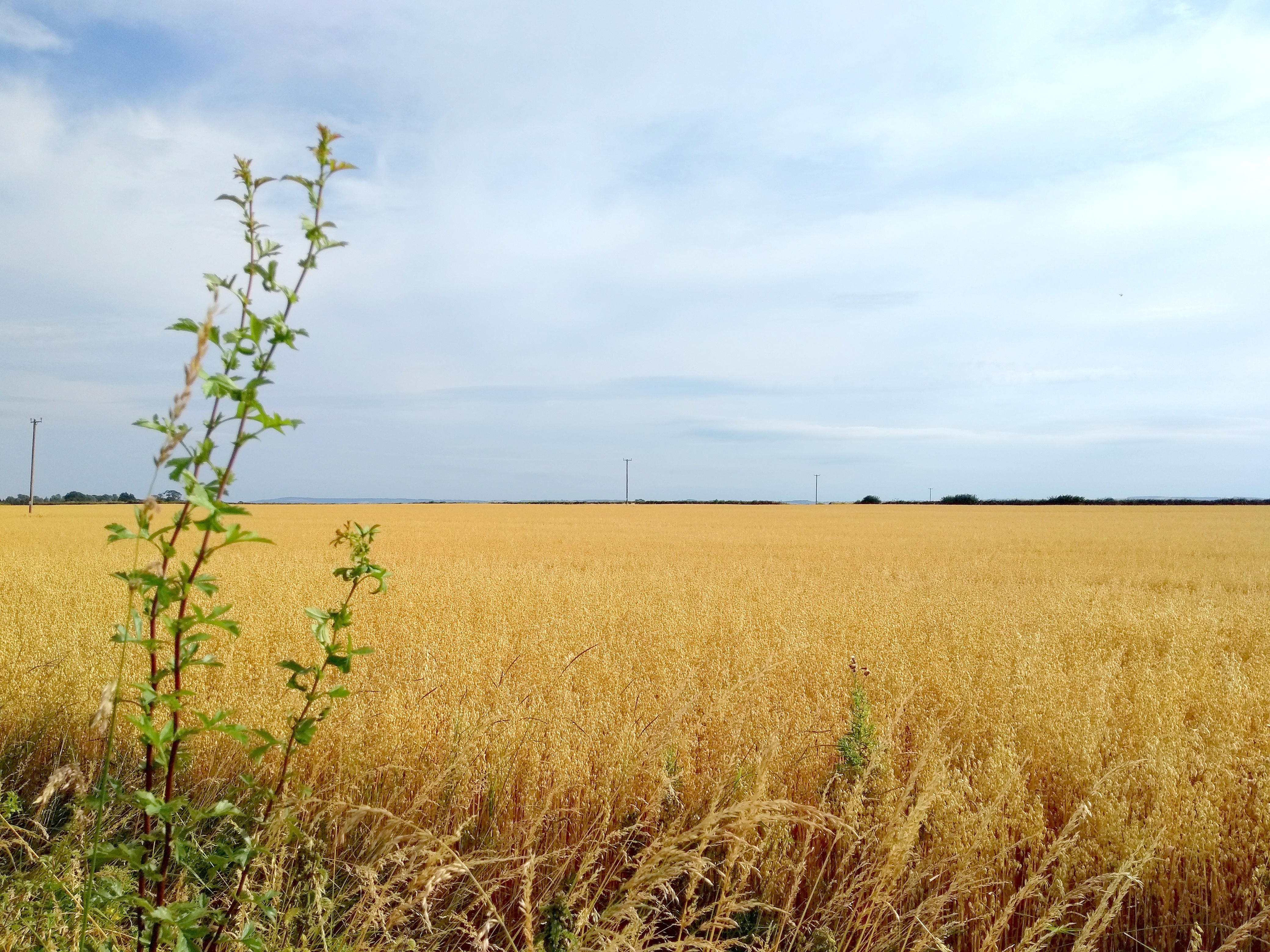
Golden Brown in Laois: Investigating the Barrow Way
 |
| © Eugene Brennan |
Kildare is a flat county, but the region of south Kildare and County Laois near Athy is characterised by exceptionally large, flat, open fields, almost prairie-like, cultivated with barley in the summer. The golden brown of the corn contrasts with the "big skies" and unobstructed views of the horizon.
 |
| © Eugene Brennan |
Apart from admiring the scenery along the Barrow Way, I spotted some interesting engineering features. The first was the Camac Aqueduct at Derrybrock in County Laois. This is a three-arched aqueduct, built over the Stradbally River in 1790, to carry the Barrow Branch of the Grand Canal. As far as I know, marl, a soft grey clay, found at the bottom of bogs, was used as a sealer for waterproofing the masonry joints of aqueducts. In the documentary series Hands, marl was also used by one of the operators of Powers Foundry in New Ross for lining the furnace to prevent the casing from being burned by the intense heat. The Camac Aqueduct seemed "leaky", water dribbling from the top of the arches. Maybe this is normal for these structures.
 |
| Camac Aqueduct in County Laois. © Eugene Brennan |
At Derrybrock Bridge near Vicarstown, I came across an OPW hydrometric measuring station, similar to the Kildare County Council owned and EPA managed one at the Mill Stream bridge on the Mass Path in Kilcullen. While the monitoring apparatus in Kilcullen is somewhat low-key and wouldn't be noticed by the casual walker, the station at Derrybrock is more obvious. A large, and what appears to be a broad-crested, flat-V weir, similar to the one in Kilcullen is used to backup the water so that it rises in level. The monitoring equipment, powered by a solar panel, projects out of the side of the riverbank. The "V" in this weir is more obvious than the one in Kilcullen, with the arms of the "V" rising up out of the water on both sides. Various types of profiles are used for weirs: rectangular, parabolic, trapezoidal, flat-V and V-notch, each having their advantages and disadvantages. Flat-v weirs are used for measurements in rivers and streams with low flow rates and narrow stream beds. Some info on the different types and flow calculations here. As I explained in the article about the Mill Stream hydrometric station in Kilcullen, weirs are used for measuring water flow. A weir causes water in a stream or river to backup and rise in level. By measuring the level using an ultrasonic or pressure transducer and doing some calculations, flow rate can be worked out. This hydrometric data can then be used for planning, water management, flood research etc. Information on the EPA's hydrometric programme is available here. It's part of the National Hydrometric Programme, with other bodies such as the OPW, the ESB and Waterways Ireland also involved in measuring water level and flow. Data from a network of over 1000 hydrometric stations around the country can be viewed on the EPA's Hydronet website.
 |
| Derrybrock Hydrometric Station. © Eugene Brennan |
 |
| Instrumentation for measuring water level. © Eugene Brennan |
 |
| Flat-V weir. © Eugene Brennan |
 |
| Flat-V weir. © Eugene Brennan |
 |
| Weir view from Derrybrock Bridge. © Eugene Brennan |