Friday, May 30, 2025

Google Maps Errors

Image courtesy Google Maps/

The map is full of errors: incorrect names on places, missing rivers and canals or they're following the wrong route, businesses in the wrong place etc. Here's the latest one I've spotted, fixed and submitted. The entire Naas Dual Carriageway from The Ball to the Red Cow Roundabout is the "Naas Byp", presumably meaning "Naas Bypass"". Maybe the whole dual carriageway has been designated as the Naas Bypass? Some of this may be due to vandalism, or people put things in the wrong place or don't zoom in sufficiently when they're adding their businesses. Routes of waterways may be created automatically from satellite images, or traced manually, but the routes are frequently wrong. Several miles of the Herbertstown branch of the Grand Canal as far as Corbally Harbour were missing up until I reported it last year.

Mouse Surgery

Circuit board from a computer mouse. © Eugene Brennan.

I've been struggling with the left button on my cordless optical mouse for the last six weeks or so. The momentary microswitch for the left button has worn out (they're good for something like 100,000 operations) and a single click is frequently doing a double click, which is really frustrating (known as "switch bounce"). I replaced the switch today with one harvested from a mouse I bought from Dealextreme and which only lasted a week before breaking down. I have a pack of five microswitches on order from AliExpress, but the double-click symptoms were getting worse and I couldn't wait any longer to fix the problem. 
 
Eugene Brennan

To get an idea of the size of the switches, they're 6 mm square as shown in the photo below.
 
© Eugene Brennan

This is the second time I've replaced the switch on this particular mouse due to it wearing out from use. It's a Microsoft Wireless Notebook Optical Mouse 4000 that's very ergonomic and a "Goldilocks" product: not too big or small, comfortable in the palm and the scroll wheel has a really smooth movement. The product is no longer manufactured and the replacement Microsoft mouse hasn't had good reviews. Also computer mice can't normally be "test driven" in stores because they're usually blister-packed, hence my decision to keep fixing this one.
 

Wave Analysis Research

Public domain image by Geralt via Pixabay.
Wave Analysis Tools is published in the journal Nature and can be used by anyone as a guide for analysing waves. Waves occur throughout nature and are typically propagated through a medium such as air, water or through the ground. Examples include sound waves, seismic waves from earthquakes, marine waves, oscillations in the components of musical instruments (e.g. stringed and wind instruments) and vibrations in structures such as bridges. It was thought in the 19th century that electromagnetic waves such as infrared, visible light, ultra violet and radio waves needed a medium for propagation. A fictitious medium called ether was invented and experiments were devised to detect it. However those experiments were in vain and we now know that EM waves can propagate through space without an intervening medium. This is how we receive heat and light from the Sun, through the vacuum of space.

This report from RTÉ has more details on pioneering wave research. 

Thursday, May 29, 2025

The First White LED

Public domain image courtesy sinisamaric on Pixabay.
I heard this on the BBC World Service Witness History programme in the early hours of this morning. Red LEDs date back to the 60s, but became more common in the 70s in consumer products such as calculators, watches, instrument displays and indicators (replacing midget incandescent bulbs). The green LED was invented in 1971 followed by a yellow version in 1972. It would be two decades before suitable semiconductor materials were developed to create blue LEDs in the early 90s. White LEDs can in theory be made by using red, green and blue semiconductor chips in an LED encapsulation and mixing the emitted light in equal proportions. However this gives poor colour rendering and inferior "quality" white light. The breakthrough came by combining blue LED technology with an integrated phosphor to convert the blue light into white light. This is similar to the way a fluorescent tube has an internal phosphor coating on the glass that converts UV to visible light. Up until the end of the 20th century, LEDS had a quite low luminous output and were primarily used for displays and as indicators. However improvements in technology have increased output dramatically, meaning they can now replace incandescent and discharge lighting in many applications. They're also typically five times more efficient than traditional incandescent lamps in converting electrical energy into light and have over twenty times the lifespan (a 100 W incandescent light bulb turns 95 W into heat and 5 W into light).

Battery Storage for the Grid

Battery storage facility for grid. Made with Bing Image Creator.
We could do with more though to act as buffers or reservoirs of energy when the sun doesn't shine or wind doesn't blow. (Think of them as the electrical analog of the flywheel on your lawn mower engine that stores energy between the power strokes). Traditional thermal or hydro power station generation is predictable and the output can be switched into the grid as necessary. Renewable generation because of its unpredictability needs the backup of battery storage to take up the slack. More info in this ESB YouTube video.

Big Picture Science Podcast — Vroom!

Generated with Bing Image Creator.
In this episode, astronomer Seth Shostak and co-host of BPS, Molly Bentley take a ride in a Waymo self-driving car. Seth also talks with Witold Rybczynski, professor emeritus of architecture and design at the University of Pennsylvania and author of the book, The Driving Machine: A Design History of the Car.

Local History Diversion

Headstone in Tournant graveyard, Dunlavin, Co. Wicklow © Eugene Brennan

Off topic again. I ended up in Tournant Graveyard in Dunlavin yesterday on one of my bicycle ramblings, to take shelter from the heavy showers under some yew trees. I hadn't been there since the 90s, so the other reason I visited was to wander around the graveyard and read the inscriptions. This Doyle headstone has lots of detail about the family's history. Tournant Graveyard is the location where those who were executed in 1798 on the village green in Dunlavin were buried in a mass grave, now marked with a memorial headstone listing all the names.

Saturday, May 24, 2025

"The Rocks", Kilcullen

The Rocks, Kilcullen. Public domain image via The Lawrence Photograph Collection, The National Library of Ireland.

Described as "The Rocks" in the Lawrence Photograph Collection from c. 1890, but I think we called them the caves. The area is pretty much obscured now behind bushes and trees, but from the vantage point of the farm trail, a glimpse can be seen of one of the overhanging sections through the vegetation. Maybe all the growth has something to do with the area being more fertile because of nutrient run-off in the river soaking up through the glacial sand and gravel deposits.
Do sand martins and kingfishers nest here? I think I could see holes in the sides when I took a walk on the trail last week.
See Brian Byrne's 2015 Kilcullen Diary article about the area, and how it has changed over the millennia and in living memory here:
https://kilcullenbridge.blogspot.com/.../the-changed-view...

Altar Headstone in New Abbey Cemetery

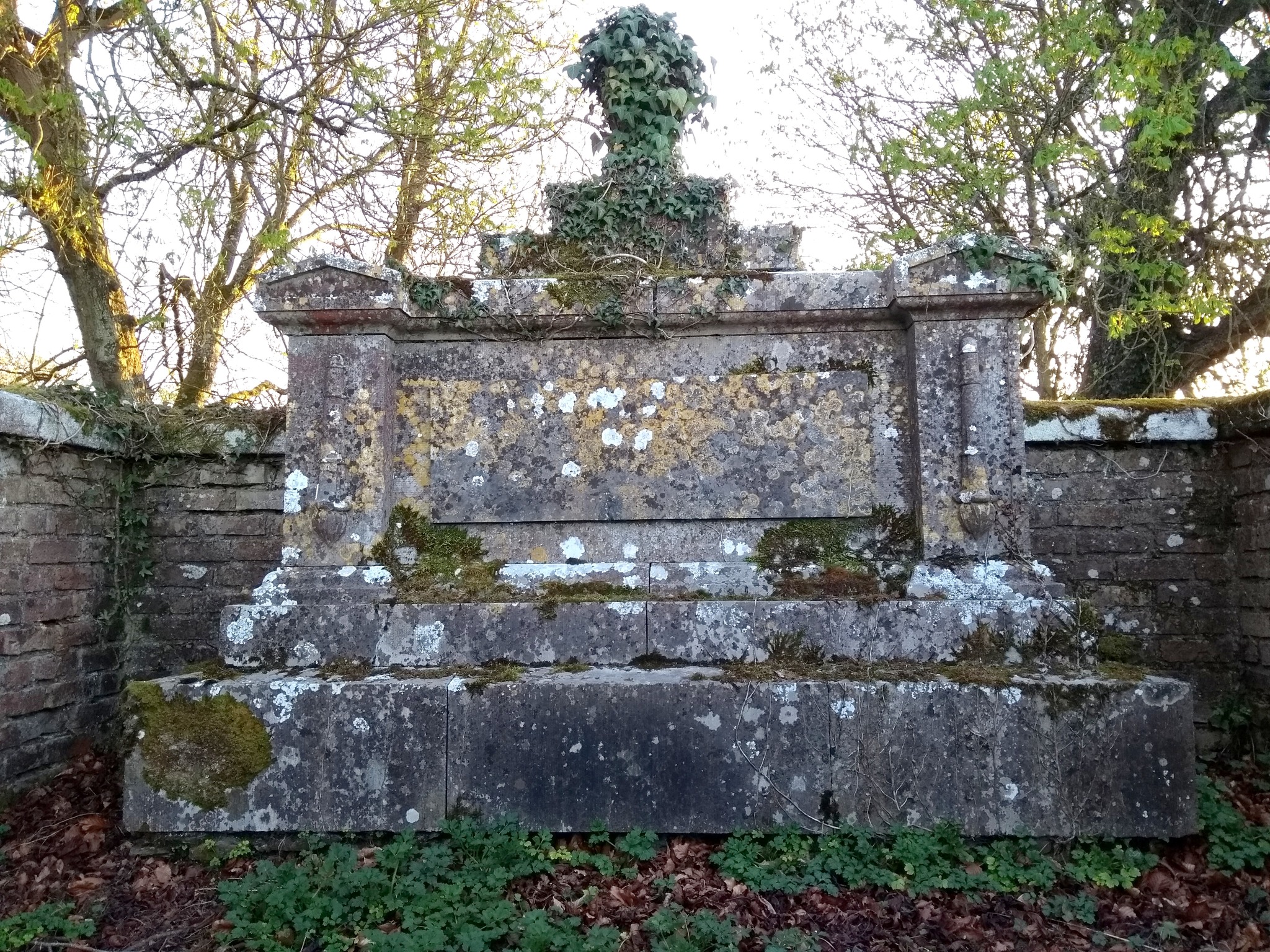
Altar type headstone in New Abbey cemetery, Kilcullen. © Eugene Brennan

Off topic again to local history. Does anyone know the history of this altar-style headstone in New Abbey Cemetery, with what I guess is neo-classical ornamentation (e.g. the urn as a finial on top and triangular pediments on top of the pillars)? I'm not sure whether "altar" is the correct term for the style and I've been doing reverse image searches on Google to see whether there's anything similar in existence, made by the same craftspeople. I seem to remember when I was around ten, the inscription was sort of legible. I can't remember ever having seen any reference to it by our local historians in The Bridge or elsewhere. Some rubbing with grass would probably bring up the contrast to allow the inscription to be read. If I ever see John Brady in the cemetery, I'll ask for permission. Climbing over the railings or wall might be necessary because the gate in the grave railings is stuck I think. Could it have been the altar from the parish church in the cemetery, repurposed as a gravestone for a member of the clergy? Meanwhile when the weather gets really dry during a drought, like now, a rectangular shape within which the grass dies appears nearby, on the opposite side of the path. I presume there's a flat slab-type tombstone just under the surface and the size and shape of the region of dead grass is similar to that of a grave slab lying some distance away. Sean Landers advised me not to start digging up the ground to see what's underneath (although I am curious!). I think it's sad to see centuries old graveyards where the grave markers belong to people long dead, with no living relatives. Maybe reading their names and thinking about them gives them a little recognition, before the inscriptions eventually erode into oblivion? Don't the people who are buried under that slab, if that's what it is, deserve to have their names revealed? Or is it better that they're forgotten?

Poulaphouca Water Levels

© Eugene Brennan

This time last year, level was 185.5 m above the datum. Now it's 185 m after having dropped to 184 m in January. Water level increased by nearly a metre in February, either due to no releases or heavy rainfall which caused a net increase. Data on Poulaphouca releases no longer appears to be available.
The "tide" was out yesterday and I managed to make my way by bike from the car park near the turn for Ballymore, around the edge of the lake to pick up the greenway. This isn't always possible because sometimes the water is too close to shore.
© Eugene Brennan

© Eugene Brennan

© Eugene Brennan

© Eugene Brennan

Friday, May 23, 2025

More Trip Hazards

Sunken manhole
If the path up to my front door suddenly sunk a bit, I'd consider it an emergency that had to be dealt with as soon as possible. Meanwhile these "manhole" covers and gate valve cover outside Armelle's Kitchen, Vape Central and the Garda barracks respectively have been like this for years, without any urgency seemingly in the need to repair them. The cover outside Vape Central appears to have been sunken by a heavy vehicle, so probably just needs to be replaced. The gate valve cover outside the barracks was reported two or three years ago.
Don't KCC understand that people with visual impairments have difficulty seeing these hazards?
When pavements are cobblelocked, perhaps it should be mandatory that a request be sent to service providers to add risers to manholes to make the covers flush with the surrounding pavement.
This isn't a comprehensive list of trip hazards. I'm sure everyone's aware of lots more around the town.
Broken manhole cover.

Stopcock cover, protruding on one side above surrounding foothpath.


Arithmetic Controversy

@TheFigen_ on X.

This has been sort of controversial on an X post. Usually BODMAS is used for precedence of operators. So to work out an arithmetic expression, calculation of what's inside brackets is done first, then orders (powers), division, multiplication, addition and subtraction. (Sometimes called "PEDMAS" for parentheses, exponentiation, division, multiplication, addition and subtraction).
So is it 6 / 2 (1 + 2) = 6 / 2 x 3 = 3 x 3 = 9
or
6 / 2(1 + 2) = 6 / 2 (3) = 6 / 6 = 1 ?

IBM Disk Drives

User RTC on en.wikipedia, Public domain, via Wikimedia Commons

In the foreground, two IBM 350 disk drives, each with a capacity of 3.75 MB and consisting of a stack of fifty two, 24 inch disks. Production began in 1957. It wouldn't be possible to store even one photo from a smartphone on such a drive and the capacity is a little over 2.5 times the storage space of the 3 1/2" floppy disks that became available in the late 1980s. Those disks replaced the earlier, lower capacity 5 1/4" disks. (I used 8" floppy disks on a microprocessor development system. This was the first format of portable floppy and became commercially available in 1971).

Thursday, May 15, 2025

Calibration of the Weir at the Mill Stream Bridge

Michael Browne from the EPA makes some calibration adjustments at the hydrometric station on the Mill Stream, Kilcullen, Co. Kildare. © Eugene Brennan

You may remember my article earlier in the year about the hydrometric station located at the bridge over the Mill Stream on the mass path. This is one of over 1000 active hydrometric stations around the country that collect flow and surface level data as part of the EPA's Hydrometric Programme. These stations monitor both surface water (e.g. rivers) and groundwater (e.g. springs). The Mill Stream station, named "Nicholastown (Kilcullen Stream)" on the EPA's Hydronet website was commissioned in October 1999, but only started recording digitally in 2009. Recordings from these stations would have either been taken manually in previous decades or using a mechanical recording system consisting of a drum chart recorder, driven by a weight, similar to the one in a grandfather clock. This recorder would have been located inside the stilling chamber (the vertical pipe at the side of the bridge) if used, although it's more likely that a digital data logger was used from when recordings began in 2009.

The concrete weir located under the bridge causes a backup of water behind it. Water level increases with increased flow. By measuring the height of water using a piezoelectric depth sensor (ultrasonic transducers are also sometimes used) and using an equation or curve-fitting technique specific to the shape of the weir, flow rate can be determined from water height. Flow rate can't be measured accurately from water speed (More information on this in the previous article). Measurements are taken every 15 minutes and telemetry data is transmitted every four hours via a GSM modem back to a central station. Although instrumentation can be powered by a solar panel or a small windmill, this station is powered by a battery. So to conserve battery power, a compromise has to be made on measurement interval, and on time needs to be minimised: the instrumentation just wakes up for a couple of seconds, takes a reading and then goes back to sleep again.

Stilling chamber containing a depth sensor for measuring water level at the Mill Stream hydrometric station, Kilcullen. Co. Kildare. © Eugene Brennan


I happened on Michael Browne from the EPA this morning on a walk through the fields to New Abbey graveyard. I was immediately curious, having worked for a company that had designed, manufactured and installed data logging equipment for local authority sewage and water treatment plants. I got chatting with Michael and discovered he was calibrating the weir. This is done every 10 weeks or so to make sure readings are correct on an ongoing basis. Vegetation can build up on the weir, causing errors in measurement and so it has to be cleaned. Calibrating the weir involves taking actual flow measurements using a portable flow meter and making corresponding readings for the height of water. Necessary adjustments are then made in the instrumentation firmware (embedded software) to the equation that converts height to flow.
I could have talked shop to Michael all day, but I didn't want to take him away too long from his work. Anyway the cattle had become curious and had come from both fields to investigate, so the place was getting overly crowded and it was time to move on...

An antenna is mounted on top of the stilling chamber for sending data back to a monitoring station. © Eugene Brennan


Archer 2, handheld computer used for calibrating the system. © Eugene Brennan

Wednesday, May 07, 2025

More BNM Paraphernalia

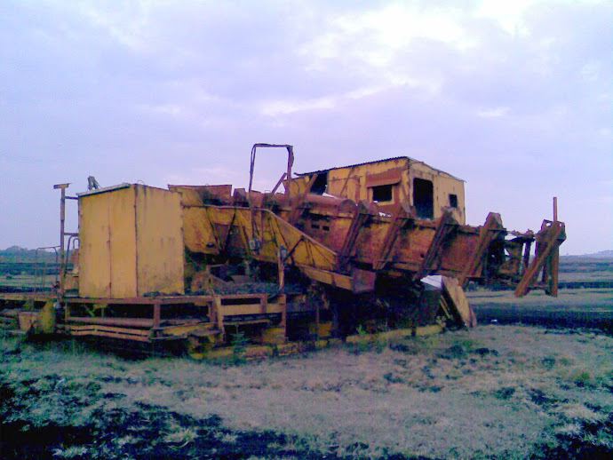
A bagger on a bog near Edenderry. © Eugene Brennan

The remains of a bagger on a bog at Mount Lucas near Edenderry, photographed in 2009 (using a dumb phone, so quality not great and I didn't have the digital camera with me). Baggers were like mobile factories, with bucket excavating arms that harvested turf, macerated it and turned it into sausage-shaped sods for burning in power stations. They were powered by a trailing cable connected to local 3.3 kV power lines. This machine was later moved to BNM's Edenderry depot and the transformer removed, I'm guessing because it contained (or they wanted to check whether it contained) polychlorinated biphenyls (PCBs), which are organochlorine compounds, once used for cooling electrical equipment and making carbonless copy paper. They are highly toxic and were subsequently discovered to be carcinogenic.
 
More information on baggers here.
 
There's also a video of a bagger in operation here.
 
© Eugene Brennan

© Eugene Brennan

© Eugene Brennan

© Eugene Brennan


The Argument for Data Centres

Data centre. Image produced by Bing Image Creator
Not my argument, this is from Publicpolicy.ie, an "online platform for informing and debating public policy in Ireland", which has recently been incorporated within the UCD Geary Institute for Public Policy.
According to Eirgrid, "By 2031, 28% of all electricity demand is expected to come from data centres and other new large energy customers".